


Saddle Mountain Hike - May 10, 2003
Mother's Day was approaching and my kids asked me what I wanted to do. If you know me very well, you've probably guessed what I wanted. I wanted to go "hiking" and have dinner at "Camp 18". When I first moved to Oregon, I had gone hiking with a group from the Chemeketans Hiking Club in Salem, Oregon. I saw the "Camp 18" restaurant while on the way to hike, and have wanted to eat there ever since. Now I am finally going to get to try out their food. (Yumm.) First we must climb Saddle Mountain!
Michael and Sylvia came over Friday evening. We had a cookout, grilling hamburgers and enjoyed the evening together. They spent the night with us Friday night, so we could get an early start Saturday morning. The drive to the trailhead was about an hour's drive away.
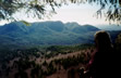
At 3,283 feet, Saddle Mountain is the highest peak in Northwest Oregon. From the summit, on a clear day, visitors have a panoramic view of Nehalem Bay and the Pacific Ocean to the west, the Columbia River to the north, as well as many snow-capped peaks in the Cascade Range to the east.
The Columbia River basalt forming Saddle Mountain erupted 15 million years ago near Idaho, pouring down the Columbia's channel, and fanned out to the ocean. Here the lava puddled up in a deep bay. When the Coast Range later rose, erosion stripped away the surrounding soft rock, turning the former bay into a mountain. The summit still has a lumpy, pillow-shaped surface typical of lava cooled quickly by water.
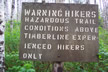
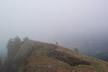
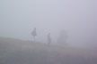
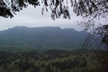
When we got to the parking lot, the weather was cool and cloudy. We took a look toward the top of Saddle Mountain and it was fogged in (darn). Decision, do we take our chances that the fog will clear up by the time we reach the top, or not climb today? We decided we were not going to let the weather keep us from enjoying our hike to the top of Saddle Mountain. Even though there was fog and clouds, which happens so much of the time near the coast, the hike was almost a surreal experience that was worth the effort. Sun, rain, clear skies or cloudly skies, hiking is always fun for me.
Three miles, that's all it is from the parking lot (elev. 1,650') to the summit of Saddle Mountain (elev. 3,283'). The trip to the top isn't an everyday stroll through the woods. The trail is smooth to start out, but then we will get to some rough terrain and some steep grades, which make for interesting climbing. Whew, what a climb, let's get started!
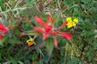
The trail is pretty easy, starting out in the forest of alder and salmonberry, then opening out into a meadowy hillside. The trail is lined with beautiful wildflowers in Spring, and some old 8-foot stumps left from the 1920's logging and 1930's fires.
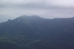
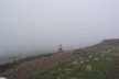
Shortly after we started our hike, there was a side trail to a bare-topped rock outcrop with the park's best view of Saddle Mountain, when it is a clear day. Even though the fog was still hanging around, Michael, who was the only one to take the side trail, did get to enjoy the partial view of Saddle Mountain.
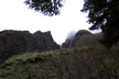
Continuing on the main trail, we switched back steeply up 1.1 miles to a narrow spine of rock running up the mountain like a stone wall. This basalt dike is actually part of the same lava flow that formed the rest of the mountain. Here, however, the tremendous weight of the flow extruded molten lava down into cracks in the ground, where the lava developed the hexagonal fractures typical of slow-cooled basalt. Exposed by erosion, the dike now resembles a long stack of cordwood.
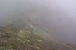
As we climbed, we stopped to take frequent breaks and enjoyed the unique landscape as well as the beauty of the forest. Even though it was foggy, we could still see some of the views and the beauty of the area.
After another half mile's climb, we came to wildflower meadows on the peak's upper slopes. It was a little too early in the year to see most of the wildflowers, although there were some in bloom. When I first climbed this trail, there were footbridges that allowed people to cross these fragile rock gardens without damaging them. This time, the footbridges were damaged and not in use. The park had put an alternate trail off to the side of the footbridges. Several rare flower species, including Saddle Mountain bittercress (a pink, 4 petaled mustard) are found almost exclusively on this summit. The alpine habitat here has served as a refuge for Ice Age species that have vanished elsewhere in Western Oregon.
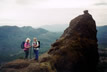
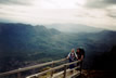
At the 2.2 mile mark, we crossed the mountain's saddle. If the weather had been clear, we would have been able to see our car down at the parking lot 1200 feet below. We could see down but not quite that far. Now, we must start our steep climb up the final pitch to the top's railed viewpoint. As we are making this climb, we can't help but notice that the fog and clouds were still hanging around. We were still hopeful that by the time we reached the top, the clouds and fog would have lifted.
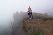
When the weather is clear, the view from the top of the mountain is one that cannot be described ... it must be experienced. When we reached the top of Saddle Mountain, we decided to take our time and enjoy our drinks and snacks. "Who know's, the fog and clouds could lift yet!" We were trying to be very positive about that! After some time of talking and visiting, Rocke and I had decided that the clouds were not going to lift and started back down the trail. Michael and Sylvia stayed behind to get a few more pictures. We had climbed back down the trail about 200 feet when Sylvia and Michael shouted at us and said that things were starting to clear up. Rocke and I turned around and climbed back up to wait with Michael and Sylvia. "Hey, it looks like it is going to clear up". "Oh no, here come some more clouds rolling in". After waiting another 15 minutes or so, we decided again it was not going to clear up enough for us to get a great view. It did clear up some for a short time, but not enough to get the coastal panorama view.
Guess we will have to do this hike again, so Rocke can experience the view from the top of Saddle Mountain. Michael, Sylvia and I have been to the top when the sky was clear and got to experience the awesome view from the top. This was Rocke's first time to hike Saddle Mountain and we were disappointed that he did not get to see the spectacular view at the top, so we will make this climb again!
Now on to "Camp 18" to enjoy my Mother's Day dinner. Camp 18 is the sturdiest restaurant in the West. A log cabin building the size of a train terminal, it features a main room supported by what the management believes to be the largest known ridge pole in the United States . . . twenty-five tons and five thousand board-feet of lumber. On the walls are massive lumber saws and old photographs of lumberjacks at work. Deep-cushioned couches surround a walk-in fireplace and many of the customers look like outdoors types, dressed in hiking clothes, jeans and flannel.
I am happy to report that restaurant was all I thought it would be. The atmosphere was great and the food was delicious!
Here is a link you can go to, if you are interested in checking out the history of this restaurant.
http://www.viamagazine.com/top_stories/articles/camp_18_02.asp
![]()
![]()